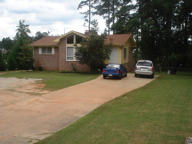
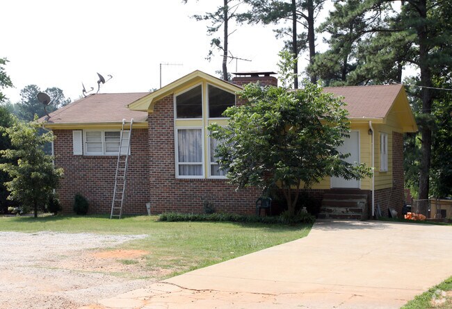
Property Record
4218 Walking Ln Nw, Lilburn, GA 30047


Save to a Folder
{{folder.Name}}
{{folder.ListingIds.length}} Properties
{{folder.ListingIds.length}} Property
Create a New Folder
Property Detail
4218 Walking Ln Nw
6-158-015
WALKING LANE
Religious
Gwinnett
C2
Georgia
B and X Area of moderate flood hazard, usually the area between the limits of the 100-year and 500-year floods.
158
2025
0.60 AC
2025
Lawrenceville/Lilburn
050441
Atlanta
2,513 SF
Atlanta-Sandy Springs-Roswell, GA
NEARBY LISTINGS FOR SALE OR LEASE
DEMOGRAPHICS near 4218 Walking Ln Nw
1 mile
3 mile
5 mile
2025 Total Population
9,920
100,090
270,418
2030 Population
10,247
103,925
280,686
Pop Growth 2025-2030
+ 3.30%
+ 3.83%
+ 3.80%
Average Age
36
36
36
2025 Total Households
3,032
33,258
90,382
HH Growth 2025-2030
+ 3.17%
+ 3.89%
+ 3.86%
Median Household Inc
$53,444
$61,773
$68,590
Avg Household Size
3.10
2.90
2.90
2025 Avg HH Vehicles
2.00
2.00
2.00
Median Home Value
$296,235
$331,515
$352,933
Median Year Built
1987
1989
1989
Nearby Places
Map Layers
Map Styles
 Street
 Aerial
Layers
 Traffic
 Biking
Places
Listings with unknown addresses are not visible on the map
- Restaurants
- Banks
- Shops
- Fitness
- Groceries
PUBLIC TRANSPORTATION
AIRPORT
Hartsfield - Jackson Atlanta International
Drive
Walk
Distance
Hartsfield - Jackson Atlanta International
45 min
32.9 mi
Freight Ports
Georgia Ports - Savannah
Drive
Walk
Distance
Georgia Ports - Savannah
300 min
264.3 mi
Nearby Properties
Address
Land Use
TOTAL SIZE
Lot Size
Zoning
Address
Land Use
TOTAL SIZE
Lot Size
Zoning
425,597 SF
49.61 AC
RM13
Address
Land Use
TOTAL SIZE
Lot Size
Zoning
338,670 SF
28.61 AC
RM
Address
Land Use
TOTAL SIZE
Lot Size
Zoning
357,946 SF
30.92 AC
RM
Address
Land Use
TOTAL SIZE
Lot Size
Zoning
444,605 SF
37.43 AC
RM
Address
Land Use
TOTAL SIZE
Lot Size
Zoning
440,998 SF
35.04 AC
RM
Address
Land Use
TOTAL SIZE
Lot Size
Zoning
464,756 SF
33.96 AC
RM13
Address
Land Use
TOTAL SIZE
Lot Size
Zoning
419,855 SF
29.83 AC
RM13
Address
Land Use
TOTAL SIZE
Lot Size
Zoning
483,912 SF
43.10 AC
OI
Address
Land Use
TOTAL SIZE
Lot Size
Zoning
525,526 SF
80.61 AC
RA200
Address
Land Use
TOTAL SIZE
Lot Size
Zoning
470,856 SF
34.99 AC
RM13
Address
Land Use
TOTAL SIZE
Lot Size
Zoning
361,593 SF
13.35 AC
RM24
Address
Land Use
TOTAL SIZE
Lot Size
Zoning
265,226 SF
18.05 AC
RM
Address
Land Use
TOTAL SIZE
Lot Size
Zoning
336,554 SF
30.40 AC
RM
Address
Land Use
TOTAL SIZE
Lot Size
Zoning
412,644 SF
23.17 AC
RM
Address
Land Use
TOTAL SIZE
Lot Size
Zoning
313,246 SF
17.15 AC
RM13
Address
Land Use
TOTAL SIZE
Lot Size
Zoning
413,878 SF
29.13 AC
CB
Address
Land Use
TOTAL SIZE
Lot Size
Zoning
332,235 SF
17.76 AC
C2
Address
Land Use
TOTAL SIZE
Lot Size
Zoning
455,471 SF
48.23 AC
R75
Address
Land Use
TOTAL SIZE
Lot Size
Zoning
364,994 SF
34.06 AC
RM13
Address
Land Use
TOTAL SIZE
Lot Size
Zoning
561,975 SF
41.78 AC
RM13
Address
Land Use
TOTAL SIZE
Lot Size
Zoning
308,378 SF
35.62 AC
C3
Address
Land Use
TOTAL SIZE
Lot Size
Zoning
420,759 SF
33.62 AC
RM13
Address
Land Use
TOTAL SIZE
Lot Size
Zoning
285,384 SF
21.32 AC
RM
Address
Land Use
TOTAL SIZE
Lot Size
Zoning
371,383 SF
29.56 AC
RM13
Address
Land Use
TOTAL SIZE
Lot Size
Zoning
287,502 SF
43.15 AC
R1
Address
Land Use
TOTAL SIZE
Lot Size
Zoning
236,654 SF
9.53 AC
RM24
Address
Land Use
TOTAL SIZE
Lot Size
Zoning
351,072 SF
20.03 AC
RM24
Address
Land Use
TOTAL SIZE
Lot Size
Zoning
283,958 SF
23.75 AC
RM13
Address
Land Use
TOTAL SIZE
Lot Size
Zoning
225,939 SF
19.79 AC
RM13
Address
Land Use
TOTAL SIZE
Lot Size
Zoning
517,654 SF
28.39 AC
RM
The World's #1 Commercial Real Estate Marketplace
Connect with us
© 2026 CoStar Group
The information above has been obtained from sources believed reliable. While we do not doubt its accuracy we have not verified it and make no guarantee, warranty or representation about it. It is your responsibility to independently confirm its accuracy and completeness. Any projections, opinions, assumptions, or estimates used are for example only and do not represent the current or future performance of the property. The value of this transaction to you depends on tax and other factors which should be evaluated by your tax, financial, and legal advisors. You and your advisors should conduct a careful, independent investigation of the property to determine to your satisfaction the suitability of the property for your needs.